|
|
Post by 2e0edx on Jul 25, 2014 15:21:18 GMT
On the road between the village of Galgate and Oakenclough there is a small hamlet called Street. It is believed that a Roman road would have passed through this area connecting the forts at Ribchester and Lancaster. The probable course of the road has been identified in this area and there are several straight sections of the present road that follow the line of the Roman road. The name Street also indicates an ancient road ran through or nearby. The River Wyre is a significant obstacle that the Romans would have had to overcome by building a decent sized bridge to enable traffic to cross. Slightly downstream from the present day bridge there are what appears to be the remains of a bridge abutment and this could be a Roman Bridge. 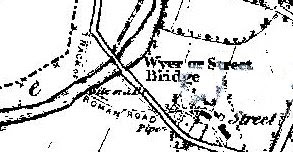 The image above is from a map of 1846, the present day road and bridge can clearly be seen and haven't altered at all. The map does show a track going to the river and it is labelled 'Roman Road'. It continues as a track on the opposite side of the river connecting up to the present road. Where this 'Roman Road' meets the river is where the bridge abutment can be seen today. I will endeavour to carryout a recce of this location over this weekend for a suitable /P activation site. 73's Ian 2E0EDX |
|
|
|
Post by 2e0edx on Jul 27, 2014 9:26:32 GMT
Managed to travel up to the Trough of Bowland, yesterday afternoon, 26th July 2014 to carryout a reccce of the Street Roman Road and Bridge CASHOTA Reference G-484.
Located the roman bridge abutment site on the banks of the River Wyre and found an activation area approximately 50M away in a field on the opposite side of the bridge adjacent to a weir.
I would hope to activate this location in the very near future on 40M SSB.
Photographs of the location were taken at the time of the recce and have been placed on the main CASHOTA website in the 'Gallery'.
Location information as follows:
CASHOTA Ref: G-484
WAB: SD55
Loc: IO83PX
73's
Ian 2E0EDX
|
|

